Location: Liwonde National Park
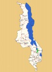
Photo: Bart Wursten
Map showing the location of Liwonde National Park
General Information
Quarter degree square: 1435C2, 1435C4 & 1535A2 Country: Malawi Habitat: Mopane woodland, swamps, floodplain grassland, riverine thickets and mixed woodland on rocky hills. Altitude range: 500 - 700 m Annual rainfall: Location (short): Location (detailed): Liwonde National Park covers an area of 548 km² and is located on the plains along the eastern bank of the Shire River plain and Lake Malombe. It was established in 1973. |
Description
The park is largely covered with mopane woodlands but there also are swamps and marshes along the Shire River and the southeastern shore of Lake Malombe, floodplain grassland in the south, mixed woodland on the hills and small areas of dry deciduous riverine thickets and semi-deciduous riverine forest.
For more information see Wikipedia.
Useful links
View a list of records for Liwonde National Park
View a list of unique taxa (excluding cultivated plants) for Liwonde National Park
View a list of unique taxa (all taxa whether cultivated or not) for Liwonde National Park